


The common mental disorders of depression and anxiety can lead to substantial disability. The possibility that characteristics of neighbourhoods, in addition to characteristics of residents, can affect mental health is of increasing interest (Reference Macintyre, Maciver and SoomanMacintyre et al, 1993). There are a number of suggested neighbourhood or contextual characteristics that might affect mental health. These include social capital, defined (after Reference PutnamPutnam, 1993) as the features of social organisation (such as networks, norms and trust) that facilitate coordination and cooperation for mutual benefit. However, neighbourhood effects might also act through the quality of the residential environment or its contribution to social cohesion, or the self-esteem felt by an individual. A few studies have measured contextual effects on mental health (Reference Birtchnell, Masters and DeahlBirtchnell et al, 1988; Reference Aneshensel and SucoffAneshensel & Sucoff, 1996; Reference Dalgard and TambsDalgard & Tambs, 1997; Reference RossRoss, 2000; Reference Ellaway, Macintyre and KearnsEllaway et al, 2001; Reference Steptoe and FeldmanSteptoe & Feldman, 2001; Reference Silver, Mulvey and SwansonSilver et al, 2002; Reference Weich, Holt and TwiggWeich et al, 2003; Reference Wainwright and SurteesWainwright & Surtees, 2004; Reference Matheson, Moineddin and DunnMatheson et al, 2006; Reference Fone, Dunstan and WilliamsFone et al, 2007) but almost all have relied on aggregated residents' perceptions of their environment or census data (compositional data) instead of independently measured contextual characteristics such as residential quality or geographical accessibility to local services (Reference McKenzie, Whitley and WeichMcKenzie et al, 2002). Furthermore, the choice of the area level to be investigated is also crucial. It has been argued that ecological associations are best explored using data for small areas (Reference Curtis and Rees JonesCurtis & Rees Jones, 1998), and the ‘home patch’ (Reference Barton, Grant and GuiseBarton et al, 2003) is increasingly seen as a useful unit for urban design, yet many studies have investigated much larger areas. In the UK, postcode units comprise on average 15–20 addresses, and often define a single street. Our aim was to investigate the amount of variation in symptoms of common mental disorder between postcode units and between households, and whether any such variation could be explained by contextual measures of residential environment quality and geographical accessibility of local services.
METHOD
Sampling strategy
The study was part of a research programme – Housing And Neighbourhood And Health (HANAH) – developed to investigate the relationships between the built environment, the social and economic context, and health. A cross-sectional survey was conducted in Neath Port Talbot County Borough in South Wales, UK. We restricted the sampling to postcodes with at least three households. Of the 3972 postcode units identified within the area by means of the Postcode Address File, a stratified random sample of 51 postcode units was selected using a probability of selection proportional to their size. The average size of selected postcode units was 20.5 addresses, although 20% contained 30 or more and the range was 3 to 86. Postcode units were sampled from six strata to represent low (bottom 15%), medium (middle 70%) and high (top 15%) areas of socio-economic deprivation using Townsend scores (Reference Townsend, Phillimore and BeattieTownsend et al, 1988), in addition to both urban and semi-urban areas.
Neath Port Talbot County Borough is the fourth most deprived of the 22 county boroughs in Wales, according to the Welsh Index of Multiple Deprivation based on the 2001 census. However, overall, areas in our sample were only a little more deprived than the average for Wales and included a reasonable spread of Townsend score values. Wales is somewhat more deprived than England on average, but direct comparison is difficult as the Welsh and English Indices of Multiple Deprivation are not comparable.
A total of 1523 addresses were identified in the 51 postcode units. As the number of addresses varied greatly between postcode units, a sampling fraction of 0.7 was applied to each postcode unit with up to 36 addresses, giving a maximum of 25 sampled addresses in these postcode units. For postcode units with more than 36 addresses, 25 were chosen at random. Of these 1523 addresses, 140 were not eligible (e.g. commercial or empty properties) and a further 148 contained only occupants who were outside the age limit of 16–75 years. In Neath Port Talbot, there were about 2.02 individuals per household on average.
Measures
Self-administered questionnaire
All residents aged 16–75 years in each sampled household were asked to complete the questionnaire survey. Questionnaires were left at 887 households (72% of the eligible sampling frame). Questionnaire distribution began on 15 May 2001 and was completed on 5 August 2001. Common mental disorder was measured by the 12-item General Health Questionnaire (GHQ; Reference Goldberg and WilliamsGoldberg & Williams, 1988), with a score of 3 or more used for case definition. The survey included additional self-administered questions regarding social capital, social cohesion, perceptions of the local area, and individual-level socio-demographic and socio-economic variables.
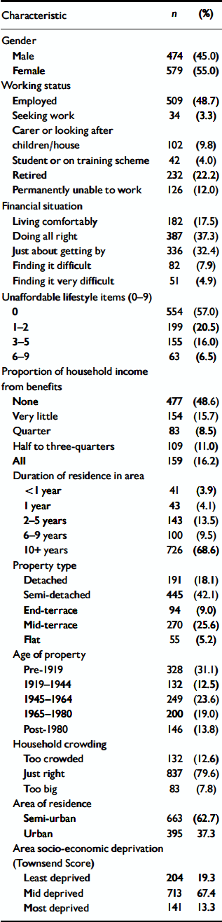
The variables listed in Table 1 were used in further analysis. Financial situation was assessed using the question, ‘How well do you feel you are managing financially these days?’ The ‘unaffordable lifestyle’ items were ‘keep household warm’, ‘keep house damp-free’, ‘keep house in decent state of decoration’, ‘replace worn-out furniture’, ‘have friends and family to your home for a drink or meal at least once a month’, ‘have a week's annual holiday away from home’, ‘have new rather than second-hand clothes’, ‘eat meat, chicken, fish or vegetarian equivalent at least every second day’ and ‘eat fresh fruit and vegetables every day’. The response ‘would like to but can't afford it’ was coded as 1 for each of these items and the total score was therefore between 0 and 9. These items are from the Breadline Britain surveys (Reference Gordon and PantazisGordon & Pantazis, 1997). Overcrowding was a self-reported item. Type and age of property were obtained from the Welsh School of Architecture database for Neath Port Talbot.
Table 1 Characteristics of the sample
| Characteristic | n | (%) |
|---|---|---|
| Gender | ||
| Male | 474 | (45.0) |
| Female | 579 | (55.0) |
| Working status | ||
| Employed | 509 | (48.7) |
| Seeking work | 34 | (3.3) |
| Carer or looking after children/house | 102 | (9.8) |
| Student or on training scheme | 42 | (4.0) |
| Retired | 232 | (22.2) |
| Permanently unable to work | 126 | (12.0) |
| Financial situation | ||
| Living comfortably | 182 | (17.5) |
| Doing all right | 387 | (37.3) |
| Just about getting by | 336 | (32.4) |
| Finding it difficult | 82 | (7.9) |
| Finding it very difficult | 51 | (4.9) |
| Unaffordable lifestyle items (0–9) | ||
| 0 | 554 | (57.0) |
| 1–2 | 199 | (20.5) |
| 3–5 | 155 | (16.0) |
| 6–9 | 63 | (6.5) |
| Proportion of household income from benefits | ||
| None | 477 | (48.6) |
| Very little | 154 | (15.7) |
| Quarter | 83 | (8.5) |
| Half to three-quarters | 109 | (11.0) |
| All | 159 | (16.2) |
| Duration of residence in area | ||
| <1 year | 41 | (3.9) |
| 1 year | 43 | (4.1) |
| 2–5 years | 143 | (13.5) |
| 6–9 years | 100 | (9.5) |
| 10+ years | 726 | (68.6) |
| Property type | ||
| Detached | 191 | (18.1) |
| Semi-detached | 445 | (42.1) |
| End-terrace | 94 | (9.0) |
| Mid-terrace | 270 | (25.6) |
| Flat | 55 | (5.2) |
| Age of property | ||
| Pre-1919 | 328 | (31.1) |
| 1919–1944 | 132 | (12.5) |
| 1945–1964 | 249 | (23.6) |
| 1965–1980 | 200 | (19.0) |
| Post-1980 | 146 | (13.8) |
| Household crowding | ||
| Too crowded | 132 | (12.6) |
| Just right | 837 | (79.6) |
| Too big | 83 | (7.8) |
| Area of residence | ||
| Semi-urban | 663 | (62.7) |
| Urban | 395 | 37.3 |
| Area socio-economic deprivation (Townsend Score) | ||
| Least deprived | 204 | 19.3 |
| Mid deprived | 713 | 67.4 |
| Most deprived | 141 | 13.3 |
Residential Environment Assessment Tool
The Residential Environment Assessment Tool (REAT; Reference Dunstan, Weaver and ArayaDunstan et al, 2005) was designed to measure directly the observable characteristics of urban residential environment. Full details of the scale and its development are provided by Dunstan et al (Reference Dunstan, Weaver and Araya2005). Residential environmental assessments of each postcode unit were undertaken over 3 days at the end of June 2001 by four raters.
The 28 environmental characteristics rated included property vandalism, stray dogs, presence of hedges and fences, garden and property maintenance, presence of recreational space, the predominant outlook (green space or buildings) and density of housing. Given the different nature of these constructs, it was decided that an overall score would require different items to be given different weights. For example, the presence of burnt-out cars would probably be given more importance than the existence of recreational space. In order to obtain these weights we conducted a separate survey of a random sample of 150 residents from the Neath Port Talbot County Borough's citizens' panel, in which they were asked the degree to which the presence or absence of each characteristic was felt to be desirable or undesirable. A questionnaire was posted and 97 (65%) completed and returned it. The survey was also posted on the local authority staff website, and a further 37 responses were received from members of staff. The results from the survey were used to generate an integer weight between 1 and 3, based on the median value of the responses to the citizens' panel survey. The scores were multiplied by the weight and summed to give a total score. The decision to use integer weights was to simplify the use of the scale (Reference Dunstan, Weaver and ArayaDunstan et al, 2005). A high overall score indicated an area of general low quality, with a greater number of negative or undesirable features. In order to perform a sensitivity analysis we also calculated a residential quality score before application of weights.
The total REAT score had a range from 0 to 68. For the 51 sampled postcode units in the borough of Neath Port Talbot, the REAT score ranged from 8 to 46 (mean 23.9, s.d.=8.3). We analysed the data from REAT as a continuous variable, but for the analyses presented in this paper total REAT score was split into thirds of the distribution (score <21.0, 21.0–27.5, 28+). The reliability of REAT scores was assessed by comparing them with ratings by a second observer. Twenty-four of the 28 items had a kappa statistic of more than 0.8. The lowest value (κ=0.58) occurred for the condition of the paths, whereas for the maintenance of shared space κ=0.67. Kappa values for the density of housing and maintenance of houses were 0.7–0.8. The intraclass correlation coefficient for the total score was over 0.9.
Geographical accessibility scores
The locations of a range of facilities were provided by Neath Port Talbot County Borough Council and were mapped on a geographical information system. Facility categories were leisure (e.g. cinema, public house, children's play park); sports (e.g. swimming pool, sports centre, playing field); transport (e.g. bus stop, train station, cycle paths); shopping (e.g. post office, local shop, pharmacy); and public services (e.g. general practice, community centre, school). The citizens' panel survey also asked residents' views on suitable levels of access. These results, together with existing indices (Reference Barton, Grant and GuiseBarton et al, 2003), allowed each facility to be allocated to one of four categories reflecting priority of importance:
-
(a) category 1: nearest bus stop, local shop, pharmacy;
-
(b) category 2: general practice, post office, cycle path, primary school, children's play park;
-
(c) category 3: playing field, public house, supermarket, community centre, children's nursery, bus station, secondary school, train station, swimming pool, sports centre, restaurant;
-
(d) category 4: cinema, non-food stores, bowling green, tennis courts.
Each of the four categories was then assigned a distance band indicating good, fair and poor levels of geographical accessibility. Category 1 facilities were assigned distances of less than 300 m (good), 300–500 m (fair) and over 500 m (poor); for category 2 the distances were less than 600 m, 600–800 m and over 800 m; for category 3 they were less than 800 m, 800–1900 m and over 1900 m for category 4 they were less than 1300 m, 1300–1900 m and over 1900 m.
An automated process using a geographical information system calculated the distance from the nearest facility to each postcode unit, allocating a score of 2 for good, 1 for fair and 0 for poor accessibility. The scores were summed to create a geographical accessibility score for each postcode unit with a range of 0–46, with higher scores indicating better levels of accessibility. The geographical accessibility scores ranged from 16 to 42 for the 51 sampled postcode units. We took a similar approach towards analysis as described above for the REAT score.
Statistical analyses
Sample characteristics and prevalence of common mental disorder were derived using commands in Stata version 6.0 for Windows to allow for clustering by postcode unit. Prior to multilevel modelling the data were analysed at a single level (again allowing for clustering) in order to help inform inclusion of confounding variables in the multilevel models. Together with the variables in Table 1, the following variables were investigated for an independent association with GHQ case status: marital status, having children at home, car ownership, housing tenure, household monthly income, total floor area of property, council tax band of property and urbanicity.
Multilevel modelling (Reference GoldsteinGoldstein, 1995) used MLwiN version 1.10 software (Institute of Education, University of London, UK). All analyses using multilevel modelling excluded the seven postcode units with five or fewer replies. Sensitivity analyses were also completed, excluding 318 households with only one response per household (while also excluding postcode units with five or fewer replies) to check the robustness of the estimate of residual variation in GHQ symptoms at the household level.
A simple variance components null model to estimate the residual variation at postcode unit, household and individual levels was fitted first using GHQ scores both as a continuous total score and a binary outcome (GHQ case v. non-case). Analyses involving the continuous outcome were based on a normally distributed multilevel model whereas those involving the binary outcome were based on a binomial multilevel model using a logit link function. Markov chain Monte Carlo (MCMC) procedures using Gibbs sampling generally provide more accurate parameter estimates (Reference Rodriguez and GoldmanRodriguez & Goldman, 2001) and these were used throughout. Individual-, household- and postcode-level predictors of GHQ were then added to the model as fixed effects in a cumulative manner and changes in variance were noted.
RESULTS
Characteristics of sample
A total of 1058 questionnaires were returned, giving a response rate of 66%. These 1058 individuals were clustered in 647 households (household response rate 73%) within 51 postcode units. Seven postcode units included replies from five or fewer participants; after excluding these postcode units the multilevel analyses were based on 1042 individuals nested within 634 households within 44 postcode units. The number of respondents per household ranged from 1 to 5, the number of households per postcode unit ranged from 4 to 25 and the total number of respondents per postcode unit ranged from 6 to 47.
The socio-demographic and socio-economic characteristics of the 1058 study participants are presented in Table 1. The average age of the sample was 46.0 years, and 55% were women. Just under half of the participants were employed and 22% were retired. Over half reported their financial situation as either ‘comfortable’ or ‘all right’, similarly, 57% reported no lifestyle item that they desired but were unable to afford. However, 13% were finding their financial situation either difficult or very difficult, and 16% reported that all of their household income was derived from benefits. The majority had lived in their area for 10 years or more. The most common type of housing was semi-detached or mid-terrace, with a wide range of ages of property. Approximately 13% of participants reported overcrowding in their house. As a consequence of the sampling strategy, the majority of respondents lived in semi-urban areas, and 13% lived in the most deprived areas.
Variance components null model for symptoms of common mental disorder
We estimated that approximately 2% (95% CI 0–6) of the unexplained residual variation in symptoms of common mental disorder was at the postcode unit level, 37% (95% CI 26–49) at the household level and 61% at the individual level (Table 2).
Table 2 Comparison of unexplained variance in GHQ total symptom score and prevalence of GHQ case status at postcode unit, household and individual level
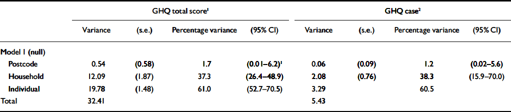
| GHQ total score 1 | GHQ case 2 | |||||||||||||
|---|---|---|---|---|---|---|---|---|---|---|---|---|---|---|
| Variance | (s.e.) | Percentage variance | (95% CI) | Variance | (s.e.) | Percentage variance | (95% CI) | |||||||
| Model 1 (null) | ||||||||||||||
| Postcode | 0.54 | (0.58) | 1.7 | (0.01–6.2) 1 | 0.06 | (0.09) | 1.2 | (0.02–5.6) | ||||||
| Household | 12.09 | (1.87) | 37.3 | (26.4–48.9) | 2.08 | (0.76) | 38.3 | (15.9–70.0) | ||||||
| Individual | 19.78 | (1.48) | 61.0 | (52.7–70.5) | 3.29 | 60.5 | ||||||||
| Total | 32.41 | 5.43 | ||||||||||||
GHQ, General Health Questionnaire
1. Results for GHQ total score based on Markov chain Monte Carlo procedures using Gibbs sampling with gamma priors for variance parameters, 25 000 monitoring iterations after 1000 burn-in iterations
2. Results for GHQ case (binary outcome) based on Markov chain Monte Carlo procedures using Metropolis Hastings sampling with gamma priors for variance parameters, 100 000 monitoring iterations after 1000 burn-in iterations
More than a quarter of the sample (26.5%, 95% CI 23.5–29.4) were scored as cases on the 12-item GHQ. The null model for the binary GHQ outcome led to similar estimates of percentage residual variation of postcode unit, household and individual level (Table 2). Although these results were consistent with those using GHQ score as a continuous outcome, the MCMC modelling of this binary outcome proved difficult as convergence was slow, with high levels of autocorrelation in the series that gave the posterior distributions of the variances at the three levels. This suggested that estimates were unreliable. We therefore decided to restrict further analyses to models using GHQ total symptom score as the outcome variable.
Including individual, household and postcode unit characteristics in the model
Individual, household and postcode unit-level fixed effects were added to the null model using GHQ symptom score as the continuous outcome (Table 3). Inclusion of the individual-level exposures reduced the total residual variation and also the percentage of residual variation at postcode level, whereas the percentage residual variation at household and individual level increased slightly. Further inclusion of either household or postcode unit exposures had a less dramatic effect on the total amount of residual variation and did not greatly alter the estimate of percentage residual variance attributable to each level.
Table 3 Effect of inclusion of individual, household and postcode unit fixed effects on the unexplained variance in General Health Questionnaire (GHQ) symptom score
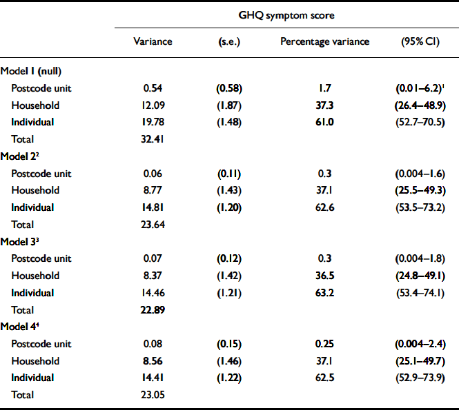
| GHQ symptom score | |||||||
|---|---|---|---|---|---|---|---|
| Variance | (s.e.) | Percentage variance | (95% CI) | ||||
| Model 1 (null) | |||||||
| Postcode unit | 0.54 | (0.58) | 1.7 | (0.01–6.2) 1 | |||
| Household | 12.09 | (1.87) | 37.3 | (26.4–48.9) | |||
| Individual | 19.78 | (1.48) | 61.0 | (52.7–70.5) | |||
| Total | 32.41 | ||||||
| Model 2 2 | |||||||
| Postcode unit | 0.06 | (0.11) | 0.3 | (0.004–1.6) | |||
| Household | 8.77 | (1.43) | 37.1 | (25.5–49.3) | |||
| Individual | 14.81 | (1.20) | 62.6 | (53.5–73.2) | |||
| Total | 23.64 | ||||||
| Model 3 3 | |||||||
| Postcode unit | 0.07 | (0.12) | 0.3 | (0.004–1.8) | |||
| Household | 8.37 | (1.42) | 36.5 | (24.8–49.1) | |||
| Individual | 14.46 | (1.21) | 63.2 | (53.4–74.1) | |||
| Total | 22.89 | ||||||
| Model 4 4 | |||||||
| Postcode unit | 0.08 | (0.15) | 0.25 | (0.004–2.4) | |||
| Household | 8.56 | (1.46) | 37.1 | (25.1–49.7) | |||
| Individual | 14.41 | (1.22) | 62.5 | (52.9–73.9) | |||
| Total | 23.05 | ||||||
1. Confidence limit does not cross zero as % variance cannot hold negative values
2. Model 1 plus individual exposures (gender, age, working status, financial status, unaffordable items)
3. Model 2 plus household exposures (proportion income from benefits, crowding in house, level of social support)
4. Model 3 plus postcode unit exposures (socio-economic deprivation category, Residential Environment Assessment Tool score)
Residential environment quality and geographical accessibility
The quality of the residential environment was not statistically significantly associated with symptoms of common mental disorder (Table 4) although symptoms were less common in areas with lower REAT scores (more attractive areas). After adjusting for the individual-level variables these differences were reduced. The geographical accessibility score was not statistically significantly associated with GHQ symptom score either before or after adjusting for individual-level variables (Table 4). The geographical accessibility of leisure and entertainment facilities was most strongly associated with GHQ score, but the association was not statistically significant either before or after adjustment for individual-level variables.
Table 4 Difference in GHQ symptom score categorised by quality of residential environment and geographical accessibility scores
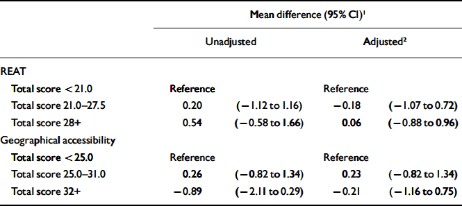
| Mean difference (95% CI) 1 | |||||||
|---|---|---|---|---|---|---|---|
| Unadjusted | Adjusted 2 | ||||||
| REAT | |||||||
| Total score <21.0 | Reference | Reference | |||||
| Total score 21.0–27.5 | 0.20 | (–1.12 to 1.16) | –0.18 | (–1.07 to 0.72) | |||
| Total score 28+ | 0.54 | (–0.58 to 1.66) | 0.06 | (–0.88 to 0.96) | |||
| Geographical accessibility | |||||||
| Total score <25.0 | Reference | Reference | |||||
| Total score 25.0–31.0 | 0.26 | (–0.82 to 1.34) | 0.23 | (–0.82 to 1.34) | |||
| Total score 32+ | –0.89 | (–2.11 to 0.29) | –0.21 | (–1.16 to 0.75) | |||
GHQ, General Health Questionnaire; REAT, Residential Environment Assessment Tool
1. Values are the mean difference between the reference category and the other categories of REAT or geographical accessibility score
2. Adjusted for gender, age, working status, financial situation and number of unaffordable lifestyle items
Sensitivity analysis
The sensitivity analysis (excluding 318 households with only one response) was based on 687 individuals within 329 households within 45 postcode units, and the results were comparable with those reported in Tables 2 and 3. For example, the estimates for the null model were postcode unit variance 0.45% (95% CI 0.0–2.78), household variance 32.4% (95% CI 22.0–44.2) and individual variance 67.1% (95% CI 58.1–77.7) when excluding households with single responses.
We also performed analyses using a residential environment score in which the weights had not been used. The correlation between this unweighted REAT score and weighted REAT was 0.98. We had very similar and non-significant non-significant results using this alternative residential score.
DISCUSSION
The most striking result suggests that approximately 37% (95% CI 25–50) of the variation in symptoms of common mental disorder is explained at the household level, whereas there appeared to be virtually no variation across postcode units once individual characteristics had been taken into account. Few previous household surveys of mental health have been able to quantify the variation between households because they have sampled one individual per household. Weich et al (Reference Weich, Holt and Twigg2003) estimated that 14% of the variation in prevalence of common mental disorder occurred at the household level in the British Household Panel Survey. Our results suggest a stronger association in GHQ score between individuals living in the same household in this much smaller area. We do not have any satisfactory explanation for this difference, but one might expect that these characteristics would vary between different geographical locations in the UK.
The proportion of unexplained variance in common mental disorder at the household level remained almost identical after adding potential explanatory household factors. Chandola et al (Reference Chandola, Bartley and Wiggins2003) reported a similar finding when attempting to account for the 20% of total variation in self-rated general health attributable to households. Household variation in mental health suggests that who you live with is more important than the internal or external environment in its effect on mental health. Other possible explanations include a household effect on perceptions and expectations of the external residential environment. The physical environment of the home might also affect self-esteem and psychological well-being either directly, or indirectly through a lack of social contact if the home environment inhibits visits from friends and family.
Our results suggest little variation in symptoms of common mental disorder at the postcode unit level. The confidence interval suggests that the maximum variation compatible with our data could be approximately 2.4% after taking account of individual and household factors. We are not aware of any previous research in the UK that has used postcode units in a multilevel model to assess the area-level variation in common mental disorder. However, previous findings from larger areas suggest that between 1% and 3% of the total variance in common mental disorder can be attributed to differences among UK regions (Reference Duncan, Jones and MoonDuncan et al, 1995), Welsh unitary authorities (Reference Skapinakis, Lewis and ArayaSkapinakis et al, 2005), UK electoral wards (Reference Weich, Holt and TwiggWeich et al, 2003; Reference Wainwright and SurteesWainwright & Surtees, 2004; Reference Fone, Dunstan and WilliamsFone et al, 2007), census tracts in urban areas of Canada (Reference Matheson, Moineddin and DunnMatheson et al, 2006) and boroughs of Amsterdam (Reference Reijneveld and ScheneReijneveld & Schene, 1998).
It is difficult, though, to exclude the possibility that larger contextual effects influence mental health. The choice of geographical category will affect the results (Reference Blakely and WoodwardBlakely & Woodward, 2000) and a balance is needed between defining an area small enough to indicate a homogeneous community while taking into consideration the fact that any inaccuracies in exposure measurement will be more noticeable in small areas (Reference JarmanJarman, 1997). Reijnveld et al (2000), for example, found more variation between neighbourhoods (areas with similar types of building delineated by natural boundaries) than between postcode sectors (designed to include similar numbers of addresses but not delineated by natural boundaries) in Amsterdam, although the results were not always statistically significant. Most research on contextual effects, including our own, has been based on administrative rather than geographic classifications and might therefore fail to detect effects because of this.
Quality of residential environment and geographical access
We did not find that the contextual measure of residential environment quality was associated with symptoms of common mental disorder. Weich et al (Reference Weich, Blanchard and Prince2002) did report that some independently rated household and neighbourhood characteristics were associated with the prevalence of common mental disorder, although multilevel models were not used to analyse their data. After adjustment, deck access properties, age of property and private gardens were associated with common mental disorder. In Chile, Araya et al (Reference Araya, Montgomery and Rojas2007) used a method analogous to ours and did find an association between the physical environment in large areas of Santiago and mental health. However, the circumstances in Chile differ in many respects from those in the UK, and socio-economic differences are more marked.
Geographical accessibility of local facilities was not associated with symptoms of common mental disorder. We are not aware of any previous studies of such a measure of access. Thomson et al (Reference Thomson, Kearns and Petticrew2003) assessed, using qualitative methods, the health impact of a new swimming pool in Glasgow, UK. The residents, especially mothers of young children, reported mental health benefits from the social contact encouraged by the pool. These data illustrate that the relationship between the provision of local facilities and mental health is complex and inadequately summarised by simple measures of distance. Likewise, a variety of other social and monetary factors can affect access.
Strengths and limitations
Our study used independent measures of residential quality and geographical accessibility, and carried out an analysis that took the hierarchical structure of the data into account. The multilevel models allowed us to estimate unexplained variation at higher levels and allowed us to model higher-level variables such as REAT scores in a robust manner. However, the study investigated a relatively small area, and perhaps there was not enough variation between our postcode units to detect using our methods. The confidence intervals for our estimates are also relatively wide and it is possible that we had insufficient statistical power to detect any differences. Furthermore, our independent measures at the highest level concentrated on the physical aspects of the environment, mostly because we thought that these could be measured reliably. The quality of the environment, the presence or absence of graffiti and the maintenance of properties also reflect something about the psychosocial environment, but we did not measure these aspects directly. We therefore did not study some of the less easily measured constructs, such as social cohesion or social capital, at the postcode unit level.
Contextual effects on mental health
The most striking finding is the considerable clustering of common mental disorder within households, in contrast to the relatively tiny or non-existent clustering at postcode level. It seems likely that the most important contextual influence on common mental disorder is that provided by the people with whom an individual lives in a household. Our research concentrated on classifying the physical environment in neighbourhoods, but our results suggest that it is the psychosocial environment that we need to understand. Perhaps future research should concentrate more upon the psychosocial characteristics of households and neighbourhoods, rather than attempting the easier task of assessing the physical environment.
Acknowledgements
We thank Neath Port Talbot County Borough Council and its Executive for their crucial support and cooperation in carrying out this study. Thanks to Professor Gareth Williams and to Mr Ben Rolfe for their help in developing the questionnaire. The research was supported by a joint grant from the UK Medical Research Council and the Engineering and Physical Sciences Research Council, grant reference number G9900679.


eLetters
No eLetters have been published for this article.